Wednesday, November 18, 2015

Abandoned Railroad: High Springs (part 1)

I live in High Springs, FL. It’s a small town with a population of just over 5000. Even though it’s a pretty small place, it’s a fairly active small town with popular restaurants, a local theater, an operational restored historical movie theater, antique stores, bakeries, and tons of outdoor activities revolving around the local rivers and springs. While many other small, north Florida towns of comparable size are indeed desolate, High Springs, in general, is not. However, the one bit of desolation which High Springs does indeed have is its abandoned railroads.

High Springs was once a fairly active railroad destination, with both a passenger and a freight railway station and a roundhouse, serving lines that ran north to south from Dupont, GA to Alachua, FL and east to west connecting High Springs to Newberry, FL and beyond. The line from Dupont to Alachua has been abandoned for many years, with the exception of a little strip here in High Springs which connected the Lamson and Sessions Prime Conduit plant just south of town along the north-south line to the connection just north of town with the east-west train line. As of 2010, the line was still active, but in desperate need of repair. A cost/benefit analysis was conducted to determine whether the line should be repaired or abandoned, and by the following year the decision to abandon had been made.

When I moved to High Springs in July 2014, the tracks were still present for the Prime Conduit to Newberry stretch of the lines, even though the rail crossings in downtown High Springs had recently been removed and the rails north of the switch had been gone for many years. In January 2015, the process of removing the rails entirely began. As of today, very little of the railroad remains in High Springs, aside from the train station buildings and the now empty railroad beds.


 photo hsrr21_zpsdu2hvepu.jpg
I took this photo in October 2014. You can still see the tracks running past the High Springs Welcome Center located in a faux-trainstation building just south of downtown.

 photo hsrr1_zps9jhwbcum.jpg
I took this on February 1, 2015, when the rails and ties had been pulled up, but hadn't yet been removed.

As I have a bit of an obsession with desolation in general and abandoned railroads in particular, I decided to explore as many of the abandoned railway lines in the area as possible. It’s a little ridiculous that two such lines exist within a few minutes’ walk of my house and yet I only just started exploring them last weekend… but what can I say? I’m a busy woman. Last weekend JOM of Gravel Cyclist and I scouted the east-west line from Poe Springs Road to the switch at the connection with the north-south line, and then followed the north-south line north of town to the Santa Fe River:

 photo hsrr18_zpssfitoktd.jpg
The east-west line, midway between Poe Springs Rd and the switch

 photo hsrr17_zps2eyk7omo.jpg
The east-west line begins curving to meet the switch with the north-south line

 photo hsrr16_zps1todkpk8.jpg
This is where the two lines once met.

The following two shots of the switch were taken at the same location in 2008 by flickr user badge1955:
 photo hsrr22_zpskrwgjprb.jpg

 photo hsrr23_zps2jw3liym.jpg

 photo hsr16_zps307ptgij.jpg
Just north of the switch, we spotted a tower.

Here's badge155's comparable shot from 2008:
 photo hsrr24_zpszbmgxf8p.jpg

 photo hsrr15_zpswosvvny1.jpg
As we approached the tower, we noticed a small building in the weeds and decided to check it out.

 photo hsrr13_zpsmevk3aiu.jpg
It had been a dispatch radio signal station.

 photo hsrr14_zpsounw1wg2.jpg
Now it's just an empty building.

 photo hsrr8_zpspicww8re.jpg
Just north of the switch and the remains of the dispatch signal station, one reaches the area where the tracks have been gone for far longer. This stretch of former rail bed has been a "road" of sorts for some time, paralleling Hwy 27 north of High Springs. It's named NW 270th Ter, and it's not exactly a highly traveled stretch of roadway. It made for a great walk on a lovely Sunday afternoon though :-)

 photo hsrr7_zpsszfqgpfa.jpg
As we neared the northern end of NW 270th Ter, we did discover this little gem off to the side. From a distance I thought it looked like an outhouse. Up close... well, as far as we could tell, it had indeed been an outhouse. While there were no fixtures remaining, there were definitely pipes in the proper places for a sink and a toilet. There were no signs of who this outhouse might have served, however, as there were no houses or remains thereof anywhere close. A pitstop for train engineers perhaps?

NW 270th Ter dead-ends at the Santa Fe River.  Not much remains of the old railroad bridge, other than a few large pilings:
 photo hsrr6_zps8g6vakeb.jpg

 photo hsrr5_zpssyayhqgp.jpg

Once you cross the Santa Fe River into Columbia county, the railroad bed becomes wild and impassable.
 photo hsrr4_zpsrwxejomk.jpg
I still plan to explore the north-south line south of town, as well as the east-west line west of Poe Springs Rd, so please check back! Meanwhile, if you're into train imagery, I recommend checking out the flickr page of badge1955, where there are a ton of excellent train photos from all over.

Thursday, November 12, 2015

Southern Columbia County

I grew up in southern Columbia County, in the area known as Columbia City (although the term ‘city’ is clearly a misnomer). I lived on five acres at the very end of a dirt road. The nearest kid my age was a mile away, and if we needed groceries it was a 30 minute drive. As a teenager, I wanted nothing more than to get the hell out of rural, desolate, backwoods north Florida. If you’d told teenage me that adult me would willingly move back to north Florida and be enjoying blogging about rural, desolate, backwoods north Florida, teenage me would have laughed in your face. However, as adult me has lived in such non-desolate locations as St. Petersburg, Russia (pop. 5 million), San Diego, CA (pop. 1.4 million), Daegu, South Korea (pop. 2.5 million), Seoul, South Korea (pop. 10 million), and Orlando, FL (pop. 2 million), living in rural north Florida in a small town with a population of 5,500 is a welcome relief. I have once again been living in north Florida for the past year and a half, and I love it. I’ve taken several drives through Columbia County to look at my old haunts and (of course) take some photos. Given my close proximity to Columbia County (I can make it there in about five minutes or so by car), I expect to share quite a few images from that county with you. Here are some of the more recent ones I’ve taken of the area around various spots in southern Columbia County, including in Columbia "city."

 photo cc13_zpslbjkmtuf.jpg
Along Hwy 47 between Fort White and Columbia City

 photo cc12_zpsn8jlfv9s.jpg
The Tube Tree at Lowe's Tubeland
In the spring and summer when the weather is hot, this is far from a desolate location, as hundreds of people come every day to tube down the
Ichetucknee River from Ichetucknee Springs.
In the off season, however, it is quite desolate.

 photo cc15_zpskoyvnfmf.jpg
The dirt road that I grew up at the end of is now paved. This one, leading into Columbia City, remains a beautiful tree-lined dirt road.

 photo cc14_zpsogmkaqgj.jpg
Want to buy your own piece of Floridian desolation? At the end of the above dirt road, right as it rolls into Columbia City, sits this house (which is for sale!)

I grew up not all that far from this house, although as its yard used to be completely wooded, and I never realized there was a house in there. Since it wasn't on "my" side of Hwy 47, this wasn't part of the woodlands that I spent my childhood romping through. I posted this picture of it on facebook, and my mom commented to say "Wasn't that the Darrell Davis house, where the guy got killed?" to which my response was along the lines of HOW WAS THERE A MURDER IN COLUMBIA CITY AND I DIDN'T KNOW ABOUT IT? I mean, kids are morbid and I would have been totally obsessed, had I known. As it turned out that it happened in 1982 when I was all of three and a half years old, it makes sense that I didn't know about it (and I doubt it would have been the sort of thing my parents would talk about in front of me). The murder occurred in the family home located behind the S&S convenience store in Columbia City, although apparently this is not the Darrell Davis house. People in the know (AKA denizens of a Lake City/Columbia County facebook group, You know you're from Lake City when...) have told me that the Davis house was a block or brick masonry house located just to the north of this one. (If you want to read more about the murder and subsequent appeal, click here.)

If you take highway 240 east from Columbia City, you will eventually come to the intersection with 441, at another booming metropolis known as Watermelon Park. There's not much there, desolate or not... other than Nettles Sausage and a boarded up old building that was apparently once a church. It's been boarded up like that as long as I can remember. I don't know what kind of church it was or when it shut down, although other Columbia County folk (again from the local facebook group) have confirmed that it was indeed once a church. Several of them mentioned that it was actually moved to its present location, although I don't have any details on when that happened or where it was located originally.

 photo wp1_zpstzewyrsj.jpg

 photo wp2_zpswdzsplnh.jpg

 photo wp3_zpsmmdi1ptu.jpg

To the southeast of Watermelon Park, there are a large number of roads named after various members of the Feagle family, an old Columbia County family. At the end of one dirt road sits the remains of the old Feagle homestead. There's not much left of it.

 photo cc2_zpsmz0vtxgy.jpg

 photo cc18_zpsbrfpayfx.jpg

 photo cc1_zpsoeuvs679.jpg
The sign in front of what's left of the homestead reads:
Home Place of David & Cora Feagle, Edith Feagle Witt, Phillip Smith Feagle, Maxie Eldred Feagle, Marion Cline Feagle

If you head further south, heading back towards Alachua county, there's another gem located at the end of another dirt road. It sits empty on a property, the owners of which appear to live in a much newer home on the same plat. I would love to have this house. As my mom had an old house moved onto her property and restored, I can totally see myself doing that one day. I'd love to move this house to my property.... if only it were available. And if only I had property, haha.

 photo cc17_zps6odkkbeb.jpg

 photo cc16_zpsnxezd2n4.jpg

Wednesday, November 4, 2015

An Abandoned Animal Sanctuary

I am drawn to desolation because I find beauty in the desolate and the decaying, but I am also drawn to the mysteries surrounding things which have been abandoned. Something inside me wants not only to explore and to photograph, but to find out what various abandoned places once were and how they arrived at their current state. Often, despite the numerous sources that are available, one can only find out so much, and the remaining mystery continues to tantalize and draw one in. My previous post about Asberry Cemetery was one such tantalizing mystery. This post is another.

I spent the other day exploring various dirt roads of north Florida, which is one of my favorite hobbies. I drove far down a narrow dirt road in an incredibly rural county, and had actually worried that the road might be blocked by a gate at some point. While I had been hoping to find something to photograph, I had expected something along the lines of an old farmhouse, however what I found was quite different. I was driving along, enjoying the view of woodland on my right and vast fields dotted with hay bales on my left, when out of the corner of my eye I thought I spotted something. I hit the brakes and threw my car into reverse, and there it was. It was an overgrown road or driveway leading into the woods, and there were faded signs – including a large, faded billboard. This had clearly once been something.
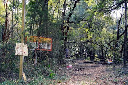
 photo acws5_zpspliyxqld.jpg

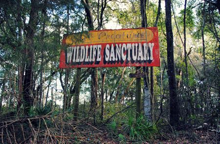
We parked the car and got out. The faded billboard read All Creatures Wildlife Sanctuary. Another, even more faded and barely readable sign read No Hunting! No Entry! We didn’t wish to trespass, but as it was clear that as neither the signs nor the facility itself had had any recent use, we ventured a short way down the overgrown drive.
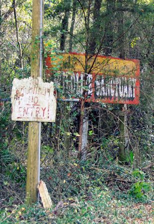
 photo acws4_zpsnvprlxyb.jpg
 photo acws2_zpssothhvmw.jpg

There wasn’t much to see, really, and it wasn’t exactly what you’d call picturesque. It was, however, both desolate and sad. All that remained of the All Creatures Animal Rescue, aside from the faded and broken signage, were some bent and mangled remains of fences, and the collapsed and stripped remains of a building of some kind.
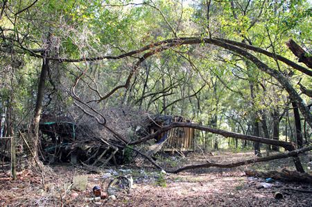
 photo acws1_zpskzrczg6i.jpg

As an animal lover, and as someone who has done a lot of animal rescue work in her life (albeit with domestic animals, not wildlife), this place really got to me. If it had indeed been a fully functioning wildlife sanctuary, providing homes to ‘all creatures’ as it were, the fact that it was now little more than a few broken signs and a collapsing pile of rubble was incredibly depressing. What had happened here? Had it really been a wildlife sanctuary? Why had it closed? Where had all the animals gone?

I thought for sure that the internet would have all the answers to my questions; however, as with Asberry Cemetery, there was only so much that I could discover.

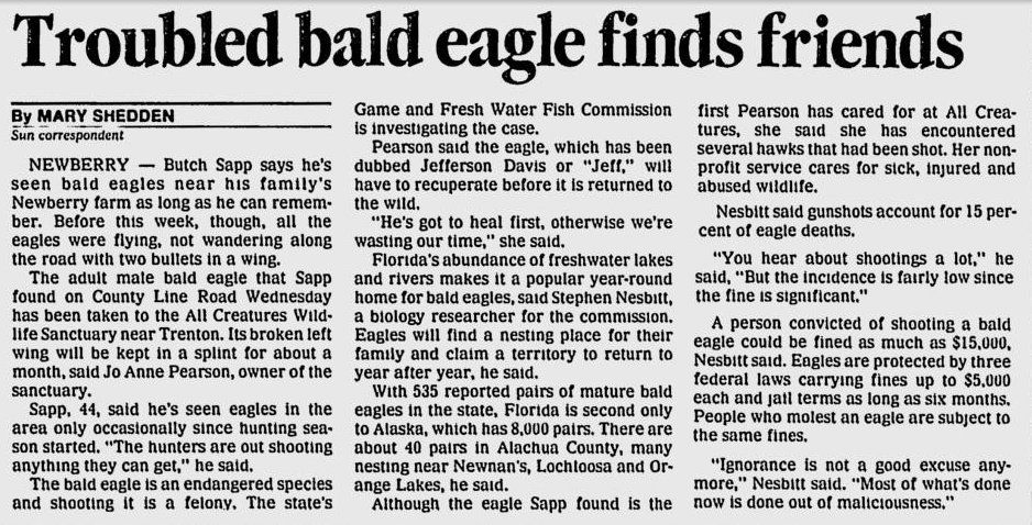
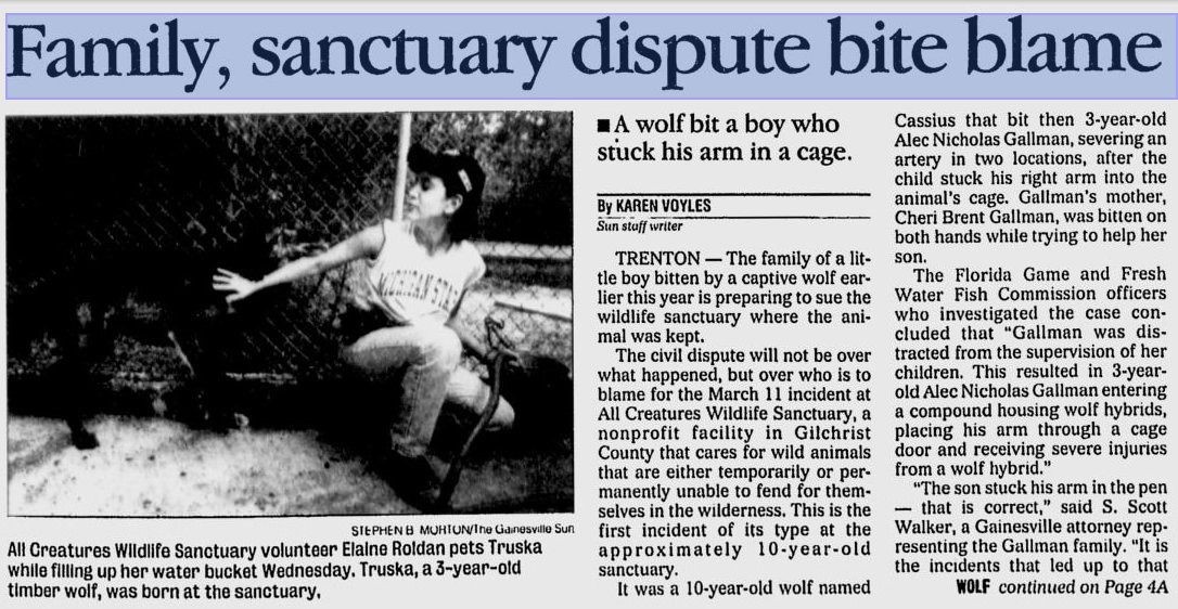
All Creatures Wildlife Sanctuary was active as a registered non-profit from 1987 to 2004. This was the most comprehensive article I was able to on the facility. According to the article, the facility was home to a wide variety of wild animals, including wolves, cougars, bobcats, owls, hawks, deer, tortoises, and more. They were federally licensed to take care for wild animals: those that had been injured and needed rehabilitation (see the article on the rescued bald eagle below), those with permanent injuries or disabilities which would have prevented them from surviving on their own in the wild, and those confiscated from unlicensed owners which had become too 'domesticated' to be released into the wild. Wild animals with shrinking populations were bred at the facility, and zoos from across the country liaised with All Creatures Wildlife Sanctuary to arrange breeding of rare animals. The facility itself ran on volunteer labor and donations. Tours of the facility were by appointment only, and cost $5 per person. Additionally, people seeking to earn their license to work with exotic wildlife, could put in their required 1000 hours of training at the facility.
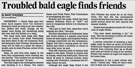
 photo eagle_small_zpsg9m30ukf.jpg
See full sized image HERE
From: Gainesville Sun, January 5, 1991

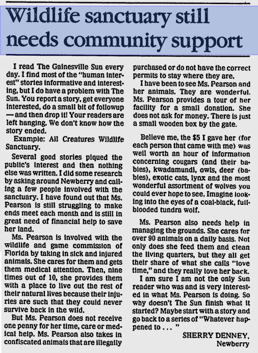
However, life at the All Creatures Wildlife Sanctuary was not smooth sailing. According to this article from 1989 (which cites another that I could not locate), the sanctuary was in desperate need of donations:
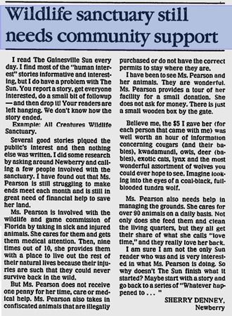
 photo don_small_zpsicfzo7qt.jpg
See full-sized image HERE
From: Gainesville Sun, August 20, 1989 

According to these articles, the sanctuary lent its male bobcat (which they used for breeding purposes) to Homosassa Springs Wildlife Park in 1990. The Homosassa Springs Wildlife Park then had him neutered, in what seems to have been some sort of misunderstanding about whether the bobcat was a loan or a gift, which you can read about HERE.

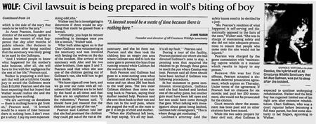
However, what I am assuming (and this is just an assumption) was the death knell for the organization occurred in March 1998. A volunteer brought her children with her when she came to the facility. She left her children unsupervised, and one of them - a three year old boy - stuck his arm into a cage with a wolf, which then proceeded to maul the boy's arm. This incident led to fines levied against the facility for negligence, a federal investigation into safety at the facility, and threats of a lawsuit by the boy's family.
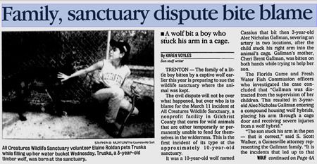
 photo bite_small_zpstryhky4x.jpg
See full-sized image HERE
 photo bite_small_page2_zpskezlbyab.jpg
See full-sized image HERE
From: Gainesville Sun, October 12, 1998

And that's it. That's where the story runs cold, at least so far as I could find. The last recorded date of activity at least in the organization's name was 2004. The property itself was sold in 2005 and again in 2006, and it has sat vacant ever since. What happened to force the sanctuary to close? Where did the animals go? I still do not know.

Sunday, November 1, 2015

Asberry Cemetery

I have to admit that, as Halloween approached, I thought that an easy cheat for this new blog would be to find an old, photogenic cemetery where I could snap some scenic-n-spooky pics to post here. I checked with Google to see if there were any cemeteries near my drive home, and noticed one - located near the end of a dirt road between Traxler and High Springs - that I'd never heard of before: Asberry Cemetery.

The road itself was quite scenic - tree lined, dirt, passing alongside numerous farms raising horses, cows, goats, and donkeys. The road didn't use to be a dead-end, although it was truncated in 1995 by the limerock mining company which purchased the large tracts of land located at its end.... as well as the property upon which the Asberry Cemetery is located. 

I didn't know any of this when I went hunting for it. I was expecting normal cemetery-looking cemetery. Instead, I came to an earthen blockade and a sign saying that the road was closed to through traffic. I was surrounded by trees and overgrowth, and there was no visible sign of anything resembling a cemetery. According to Google Maps, the cemetery was just to my south inside the wooded area. Now I am all for exploring strange and unknown places, but wandering into unknown woods all by myself in search of a cemetery – much less on the Friday before Halloween – gave a me a little bit of the heebeejeebies. I did it anyway.

On the south side of the road, in the general direction where Google claimed there was a cemetery, there was a gate leading to a cleared path into the woods. I followed it.

 photo ac1_zpsdjmyfp55.jpg
An open gate on my right; the road dead-ended behind me.

 photo ac10_zpsyh0vjntq.jpg
The path itself seemed fairly well maintained... except that it, too, dead-ended.

I expected the path to lead, perhaps to a clearing of some sort, where the cemetery would be located. Instead, the path dead ended in a giant block of limestone. There was no sign of a cemetery anywhere, and my sixth sense was definitely screaming heebeejeebies! at me, so I turned to go. Out of the corner of my eye, something glinted and caught my eye. It was a fairly new metal grave marker, but minus any sort of identification.

 photo ac9_zps3jhsdma6.jpg
Clearly a modern grave marker from a funeral home

At first I thought that the metal marker was the only grave, but as I turned to go, I spotted two more: Gertrude Wright and Catherine Mazon:

 photo ac8_zpsn1tvicq2.jpg
Remains of potted flowers sat atop one of the graves.

The graves were overgrown and surrounded by brush. At first glance, they looked quite old; however, I was surprised that when I brushed the leaves off of them the dates were actually quite recent. Gertrude died in 1989, and Catherine in 1994.

 photo ac7_zpsvifirz0p.jpg
Getrude Wright: 1915-1989

 photo ac6_zpsfqpqscxm.jpg
Catherine Mazon: 1938-1994

The idea of such recent graves, untended and overgrown and out in the middle of nowhere, was a little unsettling. I snapped some pictures and decided to head out. Halfway back to my car, I stopped to take a picture of the path, and yet again I noticed something out of the corner of my eye. This time it was a little orange survey flag… marking yet another grave.

 photo ac5_zpst6dbsqtz.jpg
Where I stopped to take a shot of the path out of the woods...

 photo ac4_zpstvbjtcqw.jpg
...and the two graves I spotted to my left.

These two graves, marking Eliza and Mark Emziah, respectively, were much older. The engraving was hand-carved. Eliza apparently lived from 1888-1918. Mark was either born in or died in 1917. There was another grave next to Mark’s with no visible writing. I took pictures, and looked around for more graves, but to no avail. Then I skeedaddled because I was feeling just a wee bit creeped out.
 photo ac2_zpsmfccytia.jpg
Eliza Emziah: 1888-1918

 photo ac2b_zps3acsotcu.jpg
Eliza Emziah: closeup
 photo ac3_zpsguhp48s6.jpg
Mark Emziah: 1917...

 photo ac3b_zpsntrlagmf.jpg
Mark Emziah: Closeup

This unmarked, overgrown, untended cemetery has haunted me for the past several days since I found it. How can a cemetery in which people were buried as recently as 20 years ago be abandoned? Who owns the property now? Why is it in the condition that it is in?

There is very little information on Asberry Cemetery available online. I found one site which labeled several individuals as having been buried in Asberry Cemetery; however, when clicking on the associated map, it turned out that what the website was calling Asberry Cemetery was actually the Spring Hill Cemetery in Traxler.

Here's an example of someone incorrectly labeled as having been buried at Asberry from billiongraves.com:
 photo wrongcemeterty_zpsajhji7i4.jpg
Close-up of the map view:
 photo wrongcemeterty2_zpsemab6z9q.jpg
Note how this is clearly Traxler; Asberry Cemetery is on the western side of I-75.

I did find one website, the Wizard of AR Alachua County Virtual Cemetery Project, which had the most information about Asberry. The goal of the website is to locate, photograph, and identify graves in cemeteries throughout Alachua County, Florida. The Wizard of AR folks visited Asberry Cemetery in 2005… and they located and photographed more than thirty graves. I saw six. There were apparently quite a few more hiding in the underbrush, and pictures of them all can be seen by clicking on the names listed on the Wizard of AR Asberry Cemetery page.

Looking through the photos on the Wizard of AR page, I noticed that several of the grave markers contained not only the names of the interred, but also the names of the funeral homes involved in the burials, specifically Chestnut Funeral Home and Duncan Brothers Funeral Home. A quick Google search revealed that these funeral homes primarily serve the local African American community, which leads me to conclude that this is an African American cemetery. I have tried to determine if there was an Asberry community or an Asberry church, but I have found no information whatsoever.

Regarding the property itself, it is on the eastern edge of a large tract of land owned by a limerock mining company (this information is courtesy of the Alachua County Property Appraiser's website, which has an excellent search function). While the property owners have clearly blocked the cemetery off with large blocks of limerock (thus explaining the large chunk of stone blocking the end of the path that I followed), and they are not conducting any mining on the cemetery grounds, they do not appear to be doing anything to maintain the cemetery itself. Benign neglect? Sigh.
 photo map_zpsayu6qmvm.jpg
From Google Earth you can see how the dirt road dead-ends in a turn-around. You can also see the limerock "wall" that not only blocks the road, but separates out the cemetery's territory from the rest of the mining territory. The 'path' which I walked looks more like a road from this shot, although it was blocked with a giant limestone rock at the treeline.